|
Dra. Dña. Karine Gadré.-
"Identifying the old Egyptian decanal stars : a research work requiring the abilities and knowledge of both Astronomers and
Egyptologists"
Abstract-Resumen: "The two last ARCE meetings gave rise
to introduce people to Astro-Egyptology, a new research area involving
both Astronomers and Egyptologists, and to detail the way Astronomers
and Egyptologists could work together in the future, within the context
of an international team or network. The soon defending of my doctoral
dissertation, before an examining board made up for the very first time
of both Astronomers and Egyptologists, will give rise to illustrate this
way of working. Identifying the old Egyptian decanal stars effectively
presupposed : 1. to gather as many ancient Egyptian starlists and
related writings as possible ; 2. to study their hieroglyphic content
and meaning ; 3. to conceive original astronomy softwares ; 4. to deduce
the most probable results from the applying of both astronomical and
egyptological criteria. Identifying the old Egyptian decanal stars
therefore required the knowledge and abilities of both Astronomers and
Egyptologists at different stages o this work. Once my doctoral
dissertation will be defended and the results published, it will belong
to the Astronomers and Egyptologists interested in this research field
to discuss about the identifications proposed."
Dra. Dña. Salima Ikram, .- "The
North Kharga Oasis Survey (NKOS): An Overview of Kharga Oasis"
Abstract-Resumen: "The North Kharga Oasis
Survey (NKOS), co-directed by Salima Ikram and
Corinna Rossi under the auspices of the American University in Cairo and
Cambridge University, has thus far worked since 2001. The goals of the
project are to explore, survey, map, and record the archaeological sites
found in the northern part of the oasis, starting from the northern
escarpment and extending to two kilometres north of Kharga town, and
extending westward to the site of Ain Amur.
The northern area of Kharga contains archaeological sites dating from
the prehistoric period to the nineteenth century AD. The most unexpected
and startling of the remains in Kharga are the forts of the Roman
period, mentioned in passing by early travellers and geologists, and
never properly investigated. In addition to the forts, the
Prehistoric sites are numerous and significant, but the millennia that
separate the prehistoric sites from the Roman forts are scarcely
documented.
As the area of the survey is enormous, and the state of preservation of
the remains uneven, a variety of techniques are used by NKOS to locate
and document the sites. The areas around the visible archaeological
remains are explored on foot, whilst four-wheel vehicles are employed
for the large-scale exploration of the surroundings. The position
of isolated features (such as cairns marking the ancient routes) is
recorded by means of a Global Positioning Systems (GPS). A theodolite
survey is carried out for areas with a particular concentration of
archaeological remains, and architectural features such as
buildings or tombs are recorded in detail to a smaller scale. Aerial
photography is not only used to document the overall appearance of
the sites, but also to identify and record ancient irrigation systems
and areas of cultivation. The research is completed with the
collection and analysis of ceramics, small objects, archaeobotanical and
archaeozoological samples.
NKOS is not only producing a map of the area, but is also trying to
understand the relationship between the different sites through the
millennia, as well as the ancient environment that shaped the oasis'
history. Beside its agricultural wealth, in antiquity the oasis was most
significant also for its strategic location in the Western Desert.
Kharga acted as a major crossroad linking Egypt, Sudan, Libya, Central
and Western Africa. As early as the Old Kingdom, the Darb el-Arbain, the
Road of the Forty Days between Middle Egypt and the Sudan, gained a
certain importance as alternative route to travellers and traders who
wished or were forced to avoid the Nile Valley. This route was
also important for strategic reasons, as the Egyptians learned in the
Second Intermediate Period when the Hyksos-Nubian alliance tried to
bypass the Nile Valley via the oases.
Thus far the team has worked at the fortress sites of Qasr el-Gib and
Qasr el-Sumayira at the northern extremity (2001, 2002). These two mud
brick fortresses are built of large sandy bricks, extending to several
storeys in height. Ain Gib was small and may have been constructed with
an eye to impressing people, rather than as a viably defensible
building. It is possible that it, together with its sister fort, Qasr
el-Sumayara, was more a location for road taxation and passport control.
The latter is a smaller structure and seems to have been the site of
settlements and industrial as well as agricultural activity, and was
probably an important provisioning station. The area south of the
fort is marked by an undulating landscape (hinting at buried
structures), intense pottery scatters, and the presence of ovens,
grinding emplacements and other industrial remains. Rock-cut and brick
build tombs with vaulted roofs lie further south, presumably built
for the more important and long-term inhabitants of the site. A complex
water-system (qanats) supported the lush agricultural fields that once
surrounded these buildings.
Further into the oasis, the sites of Settlements A, B, C, and associated
cemeteries have also been explored (2001, 2002). The settlements vary in
size and tend to be agricultural in nature, with settlements B and C
also having administrative and religious components. The tombs are, for
themost part, dug into the desert tafla and then constructed in mud
brick as single or double chambers with vaulted roofs, finished with
plaster and paint. A few rock-cut tombs have also been identified, but
these are infrequent due to the poor quality of the sandstone found
throughout the oasis.
A crossroads of the oasis is marked at the sites of Ain el-Lebekha and
Muhammed Tulaib (2002, 2004), the former of which leads to a route to
the western mini-oasis of Umm el-Dabadib. Lebekha consists of a vast
cemetery, quarries, a fort, at least two religious structures, and
houses. Muhammed Tulaib, originally thought to have been a fort, has now
been identified as a mud-brick temple that was later incorporated into a
larger structure which was eventually turned into a fortified
building. It too was surrounded by fields and dwellings, with large
cemeteries located to the east and west.
Umm el-Dabadib (2003) is located half way between the Darb el-Arbain and
the Dakhla Oasis, and included a small fort surrounded by a fortified
settlement packed with rather luxurious houses, a Christian churches, an
Egyptian-style temple located next to a spring, a slightly earlier
northern settlement, several minor ruins, a vast underground water
system, extensive cultivations and several necropolis of various size.
This site, more than the others, provides evidence dating to the
transitional period between Paganism and Christianity. Evidence of
vandalism and destruction was discovered during a check-up visit in the
fall of 2004. The temple, several tombs, portions of the fort and
associated settlements has been razed by a bull-dozer.
Further to the west, the Darb Ain Amur, the route leading to the spring
and associated Roman settlement, was explored (2004). Several graffiti
sites were identified, together with accompanying ceramic scatter. These
sites dated from the Prehistoric to the Islamic periods. One of the most
significant finds was a serekh containing the name of an unknown ruler
of the protodynastic period, or perhaps an alternative orthography of a
known king. Other finds included inscriptions from the First
Intermediate Period and the New Kingdom.
North of Kharga town the sites of Ain el-Tarakwa and Ain Dabashiya
were explored (2004). The former consists of the well-preserved remains
of a small sandstone temple, surrounded by a rectangular mud-brick
enclosure wall, several wells, and tombs. The latter consists of a
mud-brick temple, extensive cultivation, dwellings, cereal processing
areas, and several kilometres of tombs, including a canid
cemetery. One of the most significant buildings at the site is a pigeon
tower, probably of a late 2nd century AD date".
D. Francesco Raffaele, .- "Causes and Effects of the State Formation in Ancient Egypt, Late Predynastic to Early Dynastic". Lecture
sketch (Italian
Version). Las
tablas siguientes suponen un esquema de los aspectos a tener en cuenta
en cuanto a las épocas en las que se centra la conferencia para una
mejor comprensión del desarrollo de ésta. El Ponente centrará su
exposición en el título de la conferencia, esto es en las causas y los
efectos de la formación del Estado en el antiguo Egipto.
- FIRST PART -
|
Slides
|
Sketch
|
|
1. Map of Egypt
|
Introduction.
outlining the scheme and development of my discussion:
- SPACE (Upper and Lower Egypt);
- TIME (Temporal boundaries of Prehistory, Predynastic and
Dynastic periods)
- PURPOSE: Showing the millenary continuity in various aspects
of the ancient Egyptian cultural tradition within the context of
State formation (a durable process which developed along the end
of Predynastic and the beginning of Dynastic period) through the
description of some of the most important remains of the
material culture and their interpretations.
ENVIRONMENT
Stress on environmental archaeology since the 1970s (K. Butzer).
Natural barriers in Predynastic Egypt (Northern sea, Eastern and
Western 'deserts', Southern Nile cataracts)
THE
RESOURCES
- Stones, timber, gold, minerals, semiprecious stones. Plants
and animals.
- Foundation of important predynastic settlements in strategic
locations controlling trade (Maadi, Buto, Thinis, Elephantine)
or access routes to the Eastern Desert quarries (Koptos, Naqada,
Hierakonpolis).
THE NILE
RIVER
- Benefìts of annual flood (wide valley, agriculture)
- Comfortable and fast navigation (N-S communication)
- Effects of these factors in mythology, religion, rituals: the
boats (from rock-art to the funerary "Solar barks"
buried beside mastabas and pyramids, to the bark as a synonym of
'feast' in early writing, to the ceremonies involving boats
processions, the boats as a means of communication with the
Netherworld. Analogies between Nile River and Milky Way.
CLIMATE
- Pleistocene earliest dry phases (+50000 BP). Modern
palaeoclimatological studies.
- Dry Middle-Holocene (c. VIth Millennium BC) and moister
Subpluvial Neolithic (c. Vth Millennium BC)
- CONSEQUENCES of the climatic changes and of their increasing
incidence during the Predynastic:
Melting of cultures since Epipalaeolithic and Neolithic as a
result of peoples migrations caused by the sudden climatic
changes.
Common cultural features in Nile Valley,
Sudanese and Sahara Neolithic:
- Lithic industries: concave
base arrowheads
- Wavy line pottery
decorations
- Egypt as a crossover of cultures (Western and Eastern Desert
populations moved towards the Nile Valley mixing with local
peoples settled since Palaeolithic. Influxes from Near East
-animals and plants domestication-, and the Southern Africa).
- This ethno-cultural dynamism is also reflected in the field of
linguistics:
The Afro-Asiatic (Libyco-Berber, Chadic,
Ancient Egyptian, Kushitic, Omotic and North/South Western and
Eastern Semitic languages families).
NEOLITIZATION
AND NEOLITHIC
VIIIth-IVth Millennium BC in the Western Desert: Nabta Playa
Second half of the VIth millennium -Vth millennium Fayyum (Fayum
A, c. 5300-4200 BC)
- Aftermath of "Neolithic Revolution" (agriculture):
villages, more and more socially stratified societies, emerging
elites, specialization.
- BADARIAN (c. 4600-3900 BC): General features:
Settlements, cemeteries, material culture,
sustenance, trade; beginning of main socio-cultural
transformations.
Types of objects of daily and funerary use,
contacts and relationships with Fayum, Upper Egypt (Naqada I)
and Sudan (Khartoum Neolithic); social stratification evidenced
through tombs and gravegoods analysis.
|
| |
EVOLUTION OF THE ARCHAEOLOGICAL DISCIPLINE
Old excavations and past theories: late XIXth and early XXth
Century
- Different methods, aims and needs in past archaeological
excavations
Influence of 'large and medium range theories'
and of politics (colonialism) on the philosophical and
scientific thought
- Evolution(ism) (Darwinism)
- Diffusionism and "Dynastic Race"
- The "quest for museum masterpieces" archaeology
New theories and researches; modern and more specific fields of
investigation, objectives, technologies.
Live interest for Predynastic and Protodynastic Egypt;
increasing studies and publications. |
2. Chronological table
Naqada I-II-III & subphases
(aft. K. Cialowicz, 2001, 38, fig. 3)
3. W-ware evolution
(aft. B. Adams, 1988, 27, fig. 13)
4. Naqada
I-III
tombs and gravegoods
(aft. B. Adams, 1988, 16, fig. 4 with some modifications)
|
THE
PREDYNASTIC CHRONOLOGY
The three phases
of Naqada Culture. How was this subdivision achieved?
- W.M.F. Petrie: Amratian, Gerzean and Semainean. Contexts'
seriation (1899, 1901, 1920).
Sequence dating and the bases of relative chronology. The
units groupings SD: 30-39, 40-62, 63-80.
- Typologies and artefacts corpora (influence of the
Evolutionism)
- Wavy-handled ware development
- W. Kaiser: Armant cem. 1400-1500 and the Naqadakulturstufen
(1957, 1990).
- S. Hendrickx: further improvement to the system (1989, 1994,
1996, 1999).
- Terminology: "Late Predynastic",
"Protodynastic", "Archaic Period" and dynasties.
|
- SECOND PART -
|
5.- 6. Palettes
7. - 8. C-ware vessels
9. Gebelein textile
|
NAQADA I (c.
3900-3600BC) Matmar - Kubbaniyeh area with its core in the Qena
bend (Diospolis, Naqada)
- Upper Egyptian
culture
(links with Badarian and Sudanese facies; differences with Lower
Egyptian culture)
- Increasingly marked social stratification (particul. in Naqada
Ic-IIa). Tribal societies and simple chiefdoms
- Few traces of semi-permanent settlements. Sustenance
activities and interregional contacts.
- Rock art of Western and Eastern Desert. Interpretation and
stylistical analogies.
- Grave-goods and their typological evolution; their practical,
and magic-symbolical purpose
B, C, P ware and stone vessels
Cosmetic schist palettes ('slate'): practical
and ritual use
rhomboidal
palettes with rare incised motifs (elephant, hippopotamus hunt,
symbols)
zoomorphic
palettes (fishes, amphibious, mammals) and early pelta
shapes
Magical/apotropaic amulets
Pottery figurines and statuettes (praying
women, wild/domestic animals, barks...)
Mace-heads (disk shaped)
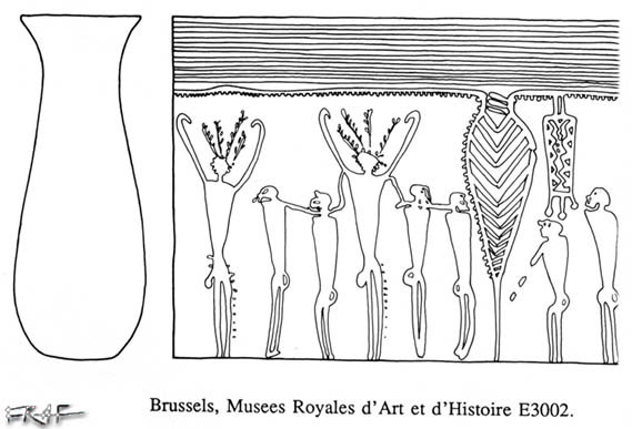
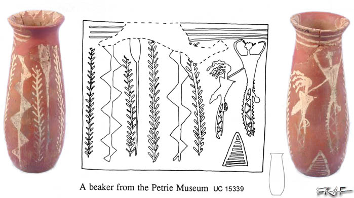
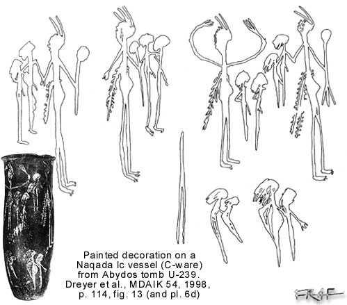
- Interpretation of C-ware decorations (types of motifs and
scenes; regional styles)
Representations of human beings (Brussels E3002,
London UC15339,
Abydos t. U-239)
(earliest violent
rituals and high-sized portraits of chiefs/gods)
- The
Gebelein textile
in Museo Egizio, Turin (suppl. 17138).
Date (late Naqada I- early Naqada II [Naqada
Ic-IIa(b), c. 3550BC]
Resemblance with scenes and motifs painted on
C (and D) pottery and incised in Desert rock art.
The Heb Sed (anthropology of regicide;
purpose, phases/ceremonies, periodicity of historical Heb-Sed)
- The oldest traits of sacred/divine kingship begin to emerge:
The king as a champion/hero/annihilator of
foe/chaos and partisan of Maat:
Hippopotamus
and other wild beasts hunt
Royal attributes:
Crowns,
feathers/horns on the head, bull/lion tail, penis sheath, sticks
and scepters
- Elites and chiefs:
Cemeteries: separation of nuclei of tombs
belonging to the ruling classes. Statistical analysis and other
data
(wider,
better built, more and better furnished tombs)
global synthesis
and comparison of Naqadan cemeteries: J.J. Castillos, B. Kemp,
K. Bard, T. Wilkinson
Some 'Amratian' tombs:
Hierakonpolis,
Locality 6, t. 14, (c. 10 years old elephant, Naqada Ic period)
Naqada, t.
1610 (red crown relief on a B-ware sherd)
Abadiya,
tombs 101, 102
Abydos,
earliest tombs in U-cemetery: tomb U-239.
|
10. Nile
Valley
model-settlement
(aft. B. Williams, 1994, 277)
11. Cultural
and political regional units during Naqada II
(aft. B. Kemp, 1989, 34, fig. 8)
12. - 13.
D-ware vessels
14:
Hierakonpolis painted tomb 100 and Naqada tomb T5
15. Tomb 100
painting
16. Detail of
the painting
|
NAQADA II (c.
3600-3350/3300BC) Northward and southward expansion of the
'Gerzean' cultural area'.
- Higher
structural complexity of society: ruling élites and developed chiefdoms.
Coercive strategies.
- Central and peripheric settlements
Alluvial
settlements on ancient Nile islands in strategic locations for
the control of wadis and/or trade
Fortifications
(mud walls or palisades): permanent settlements and
sedentarization
- Propensity for cultural-territorial encroachment towards Lower
Egypt and Lower Nubia
- All-levels specialization (ideological, technological,
artistic, political-organizative, commercial)
- Material culture
'Bearded men' statuettes (ivory, stone)
Stone vessels fashioned in several shapes
Mace-heads (pear-shaped)
Knife handles (extreme skill in working and
retouching the ripple flake flint), flint animals
figurines
Palettes (zoomorphic, scutiform/shield-shaped)
Amulets (Bull head, small palettes)
Pottery: R-, D-, W-ware
Objects of personal and domestic use
- The sense of D-ware paintings (more standardized than the
previous phase ones):
(representations
of the Underworld, of ceremonies/rites/funerary
processions, legends/folklore, divinities...)
- Cemeteries and
tombs of regional leaders (Hierakonpolis loc. 33, loc. 6; Naqada
T)
Crude mud brick, large rectangular tombs,
funerary gravegoods and exotic materials ('powerfacts').
Hierakonpolis
tomb 100 (size: 4.5 x 2.0 x 1.5m; date: Naqada IIC, c. 3450BC)
Main
motifs of the wall painting:
Boats
procession. Mace armed chief smashing the enemies' heads. The
"lord of the animals".
Conflicts. Hunt. Trapping.
Early
prototypes of base-lines (registers).
(Analogies
with the Gebelein textile and the D-ware decorations).
Interpretations proposed.
- Mesopotamic/Elamite influences (Uruk V-IV, Susa II)
Statuettes,
iconographic features, imported seals.
|
17. Gerzeh palette
18. - 19. Hierakonpolis palette
20. Gebel Arak
knife handle
21. Abu Zeidan knife handle
22. Carnarvon knife handle
23. Gebel Tarif knife handle
24. Seyala mace handle
25. Qustul
incense burners
(aft. K. Cialowicz, 2001, 61, fig. 2)
|
NAQADA II-III
TRANSITION
- Cultural
expansion to the area East of the Fayum (Gerzeh, Harageh, Abusir
el Meleq) and into Lower Nubia
- Earliest seal-impressions from Abydos U-cemetery (implications
for the administration development)
- Earliest relief decorations on the surface of palettes (Manchester/Ostriches,
Gerzeh,
El-Amrah/Min)
Proposed
interpretations and implications for the formation and
development of ruling classes' ideology
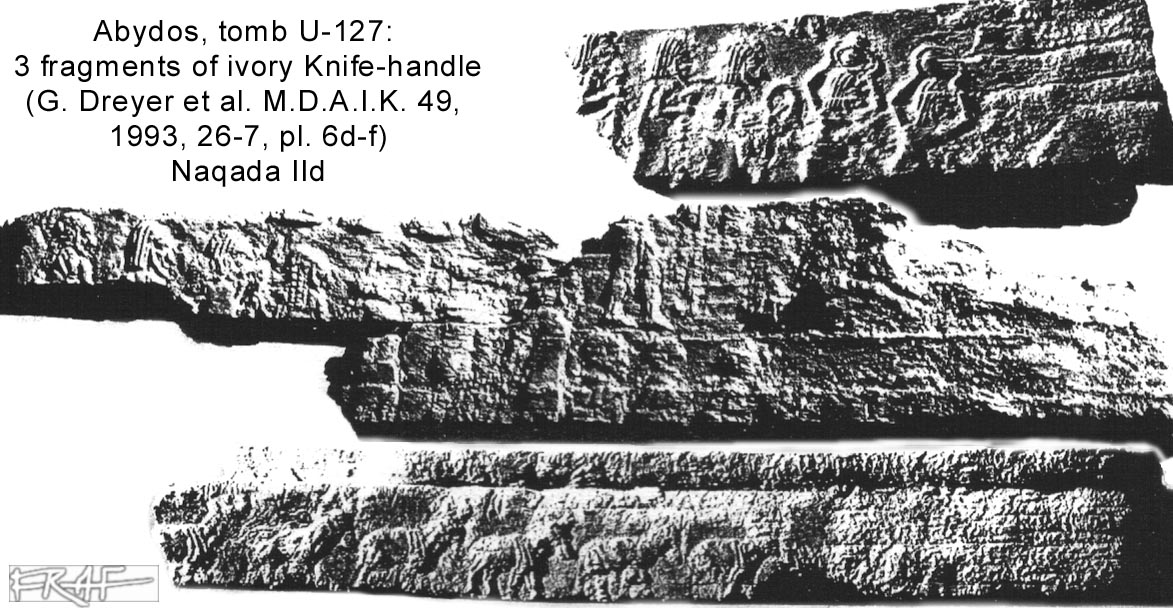
- Knife
handles
(attached to the most beautiful ripple-flake flint blades
ever worked out)
- Interpretations proposed
for the carved scenes and motifs
(ordered
animals rows; processions of soldiers, prisoners, offering
bearers, boats; battles)
- Ritual-symbolical
use/purpose of these prestige objects.
- Relative and absolute
datation:
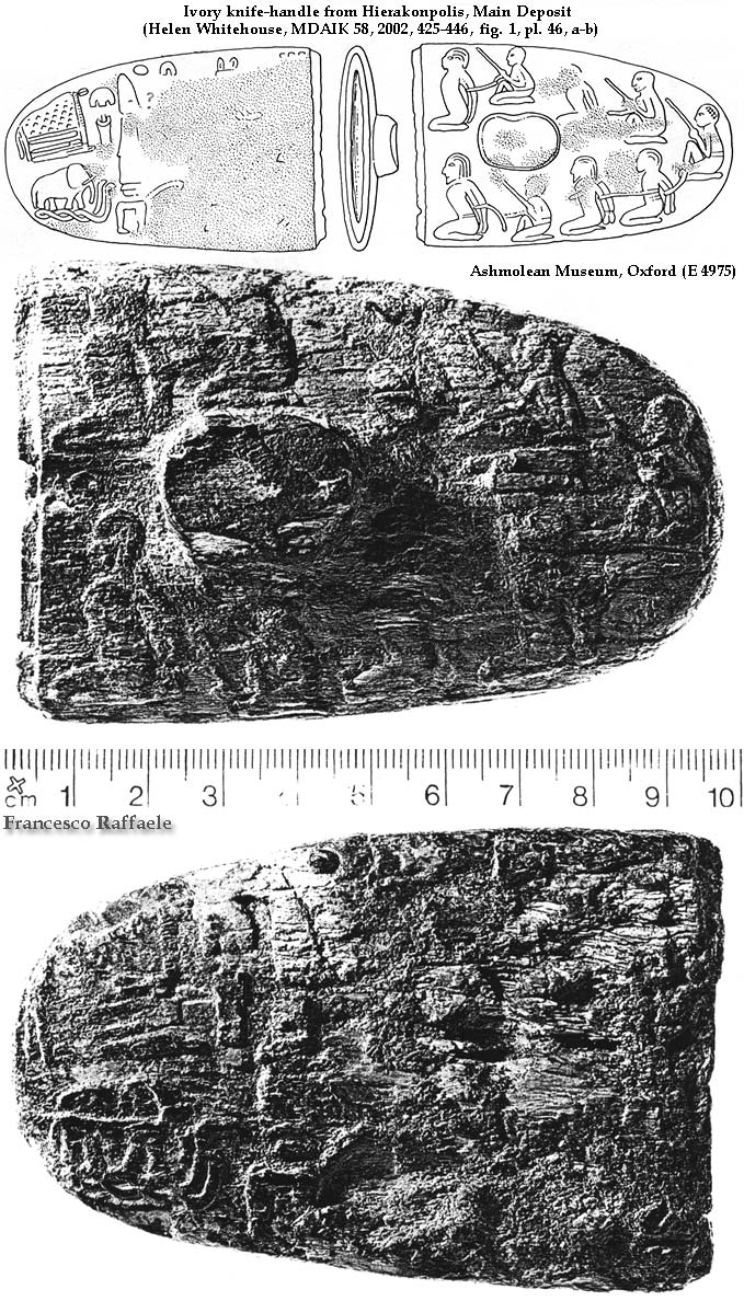
New ivory
handles from Abydos (cemetery U, t. 503,
127);
recently cleared one from Hierakonpolis (Ashmolean
E4975)
- Examples of ivory
knife-handles:
- Gebel el-Arak (Louvre
Museum)
- Abu Zeidan (Brooklyn
Museum)
- Carnarvon (Metropolitan
Museum)
- Gebel Tarif (Cairo Museum)
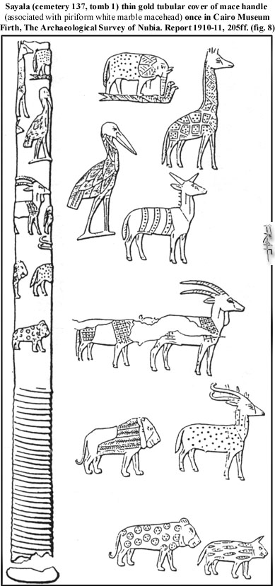
gold handle
- Mace-heads (pear-shaped) with carved ivory handles or with
incised/hammered gold-leaf handle cover
Seyala
mace
(cemetery 137, tomb 1)
Ideological
background and ritual use. Stylistical resemblance to the Gebel
Tarif handle decoration
Origin
(Egyptian manufacture and gift of an UE chief Nekhen or Nubian
origin?).
- Digression on Lower Nubia 'proto-states' (Ta-Seti)
early in Naqada III (Qustul, Seyala, Afieh).
A-Group (classical and terminal). General
features.
The great 'royal' tombs of cemetery L at
Qustul and prestige objects (incense burners, seals, stone
vases...)
Relationships with Egypt and Palestine. Long
distance trade.
B.B. Williams' hypothesis on Ta-Seti and the
origin of Egyptian tradition (bias and confutation).
|
26. Model
landscape and stages of formation of ruling centres from small
hamlets and villages: political expansion
(aft. B. Kemp, 1989, 33, fig. 7)
27. Naqada III:
the 'Proto-kingdoms'
28.
Chronological table
|
NAQADA III:
GENESIS OF A STATE (from
3320/3300BC to Early Dynastic period):
The cradle of
State Formation
- Macroregional "proto-states" in Upper Egypt.
Enlargement of political-territorial units
which absorb the closer ones
Anthropological
theories on the origin of ancient states:
-
Mono-causal hypotheses (environment, population pressure,
trade/resources monopoly, low resources competition, hydraulic
technology, war, personal authority and decisions)
-
Multi-causal theories (more factors at work, their interaction
and feedback)
Biases, limits and possible
evaluation/interpretative mistakes in reconstructing the
relevancy of old politics from the archaeological data (more or
less known and documented cemeteries).
Towns in (pre-)dynastic Egypt
- Causes of the
scanty archaeological evidence of urban sites
(modern cities, deep stratification of alluvial deposit,
sebakkhin)
- Nile Valley
archaeology: an unbalanced knowledge
(much
better known, with but few exceptions, for/from cemeteries than
for settlement sites)
- The picture
from the Delta according to the two recent decades of
archaeological campaigns
- Lower Egypt:
General features of ancient Maadi-Buto culture late in Naqada I
up to early Naqada II
(less
social inequalities emerging from funerary contexts, emphasis on
trade with Southern Canaan)
- Naqadization of Northern Egypt (apparently
non-traumatic cultural superimposition)
Gerzeh,
Harageh, Abusir el-Meleq area during Naqada IID
Nile
Delta: Tell Fara'in-Buto, Minshat Abu Omar, Tell Ibrahim Awad,
Tell el-Farkha (Naqada IID-IIIC)
(the
"Transitional layer"; scarce traces of destruction and
struggles)
- Reasons of the spreading of the Naqada culture
(population
pressure, monopoly of trade with the Southern Levant)
Formation and canonisation of divine kingship
Rulers start to appropriate symbols, objects
and attributes proper of the previous periods' leaders
(iconography of
powerful individuals portrayed on rock-art and artifacts
decorations during the first half of IVth millennium BC)
|
29. Abydos.
Plan of Cemetey U
(aft. G. Dreyer, 1998, fig. 1)
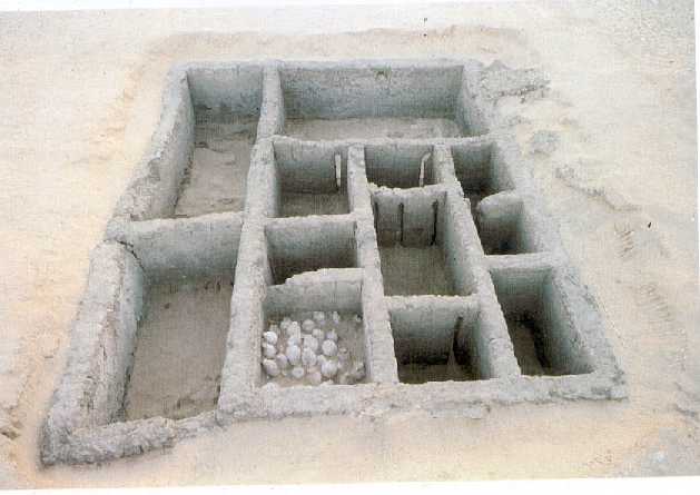
30. Abydos, tomb U-j (photo)
31. Abydos, tomb U-j (plan)
32. - 33. Some inscribed tags from tomb U-j
34. Scorpions
(ink inscribed on cylinder jars)
35. Seal
impressions from Abydos cemetery U
36. Koptos
colossi
37. Predynastic
kings list (as reconstructed by G. Dreyer)
38. Gebel
Tjauti graffito
|
ABYDOS
(THINIS) DURING NAQADA IIIA
- Abydos Cemetery
U. Tomb U-j
Absolute and relative datation: c. 3300±50
BC, Naqada IIIA1
The constructional features: 2 crude mud-brick
courses; size 9.10 x 7.5m, 12 rooms, 2 building phases
Reconstruction of the tomb
as a model royal palace (slits between the chambers). The
southern Opferplatz.
Principal findings from tomb
U-j:
ivory heka
scepter,
c. 2000 vessels
(about 1/3 of which were Palestinese imports)
carved ivory
knife-handles fragments
small
obsidian vase decorated in the shape of two hands
bone and
ivory tags (150+) with incised hieroglyphic indications
ink
inscriptions on cylinder (W) vessels (scorpion, shells,
bucranium, fish...)
- The Egypt most ancient
true writing attestations:
Administration and royal propaganda; morphological
characteristics
Examples
of reading/epigraphy of some tags' signs
-
phonetic reading of places where the labelled containers and
their contents came from
(Bubastis,
Buto, Abydos districts, Elephantine, some nomos; cf.
Kahl, in: CdE 2003)
-
ideographical, logographical, phonetic signs; numerals.
- The alleged "King Scorpion" and the predynastic
kings list proposed by G. Dreyer:
Dreyer's hypothesis and recent critics to his
reading of the royal names (including Scorpion's own one)
(Kemp, Kahl, Breyer)
- Political status of the owner of tomb U-j of Abydos: Thinite
chief or king of an already unified Egypt?
- Seal impressions from cemetery U: the meaning of scenes/motifs
and socio-administrative implications
The
earliest Egyptian seal impressions:
Naqada
(tombs and South Town), Naga ed-Der, Mahasna, Matmar, Abusir
el-Meleq...
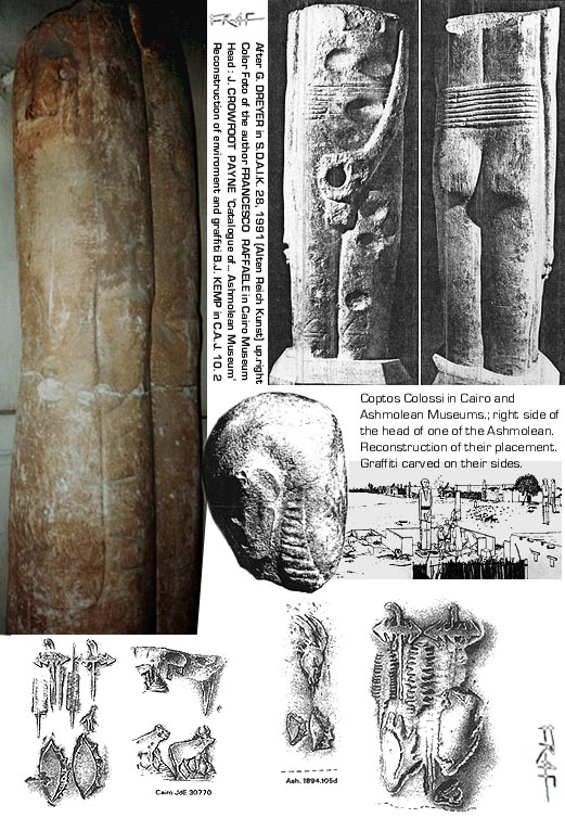
- Religion and (monumental) statuary: the Min
Colossi
from Koptos:
stylistical analogies (Mac
Gregor
statuette in Ashmolean Museum, Oxford)
inscriptions/reliefs
and their possible meaning (kings names; gods and/or localities
emblems/names)
- B. Williams' identification of
Narmer's name on the Cairo Museum colossus, and its relevancy
for Dreyer's kings' names hypothesis: critics to both the
reconstructions
- parallels between the signs on
the Colossi and those found on other objects
- War and submission: Gebel Tjauti tableau 1
- description and
interpretations (both in political and in symbolical key)
(T. Wilkinson, R.
Friedman/S. Hendrickx, J. Kahl)
|
|
|
NAQADA IIIB:
TOWARDS THE POLITICAL UNIFICATION OF EGYPT (c. 3200-3050 BC)
- Hypotheses on
the modalities of Egyptian political Unification
(Kaiser, Von der Way, Trigger, Kemp, Köhler,
Campagno)
- Conflicts with neighbouring peoples (Libya, Delta, Asiatics,
Nubians, Bedouins) or internal conflicts?
Violence as a magical-symbolical-apotropaic
need or as a mirror of real socio-political tensions?
Palettes with violent
scenes (Battlefield, Tehenu, Bull palettes), brief description
and interpretations
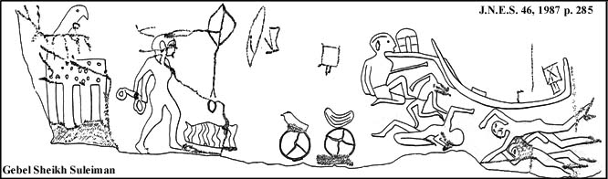
- The oldest anonymous serekhs from the southern part of
U-cemetery at Abydos. What is a serekh?
- Royal ideology propaganda or real events chronicles? Decorated
objects and rock-art:
The main graffito at Gebel
Sheikh Suleiman and the beginning of the A-Group decadence
(global
sense of the scene and some fresh notes on the anonymous serekh)
- King Scorpion (II) at Hierakonpolis: his mace-head in Oxford,
Ashmolean Museum (E3632)
The rosettes in Late
Predynastic Egypt.
King Scorpion: a Thinite or
a Hierakonpolite ruler?
- HIERAKONPOLIS (Nekhen):
The site, Horus temple,
'main deposit', Locality 29A ceremonial centre, Locality 6 élite
and animal tombs
Which role did Hierakonpolis
play in the Late Predynastic political panorama?
- "Dynasty
0": Thinis/Abydos, Hierakonpolis and other regions' kings
('Crocodile': a Fayum Gegenkönig?)
|
- THIRD PART -
47. Narmer
mace-head
48. - 49. Narmer palette
50. Abydos:
subsidiary tombs B16 (Horus Aha)
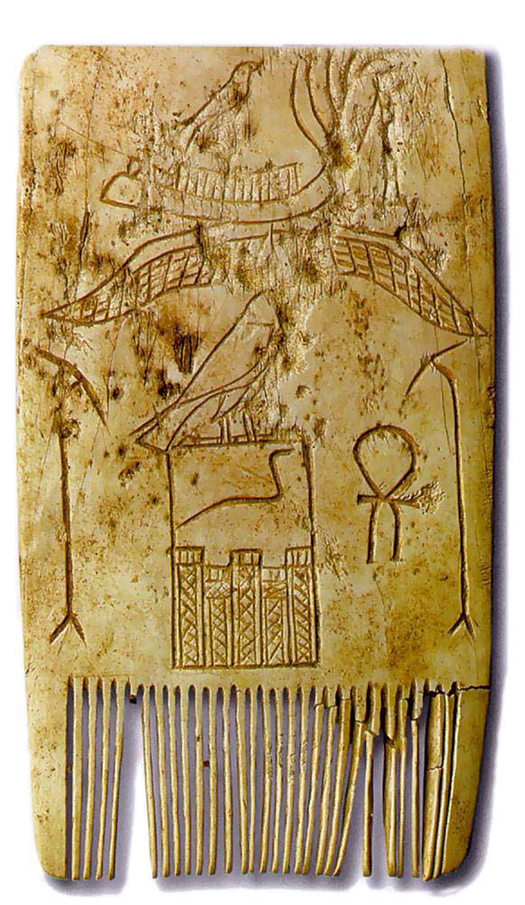
51. Djet comb
(Louvre)
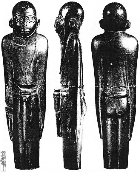
52. Ivory
statuette of a king wrapped in the Heb Sed garment (from
Abydos)
53. - 54.
Saqqara mastabas
(First Dynasty)
55.
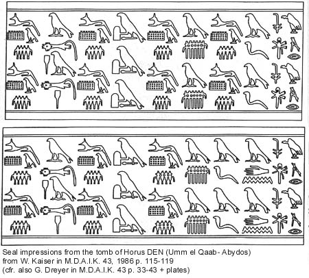
Hemaka/Den label
56. Merka
stela
(Saqqara tomb S3505)
57. The royal necropolis at
Abydos, Umm el-Qaab:
tomba Q
(Horus Qaa)
58. S3507,
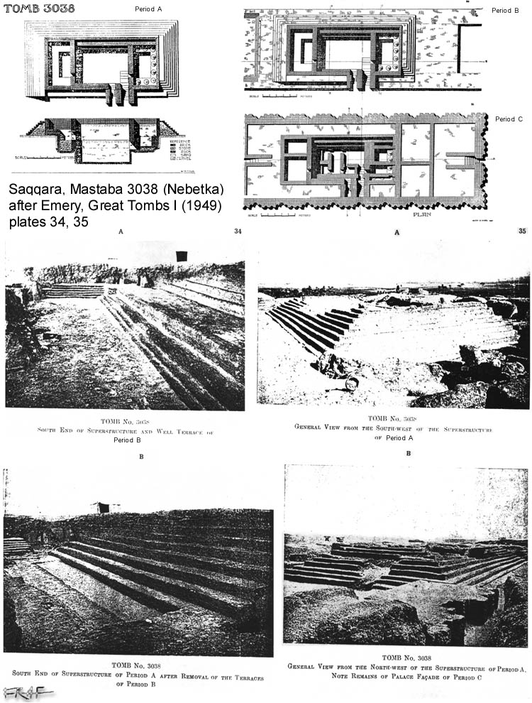
S3038 and
Djoser complex/pyramid
59. Saqqara,
tomb A
|
NAQADA
IIIC-D: THE FIRST DYNASTIES AND THE NEW BORN STATE
The definitive
"Political Unification" (?)
- Narmer's mace-head and palette:
description and interpretations offered
(again,
chronicle of real events or symbolic representations?)
The
identity of the defeated ones (theories) and the meaning of
the single acts and motifs shown
- Narmer reign (the apex of southern Palestine contacts):
Digression
on the relations between Egypt and Levant all through the
Early Bronze I (EB I, c. 3500-3000BC)
-
the nature of contacts with the 'colonies' in Palestine
(Lebanon, Syria) (wine, oils, timber)
('En
Besor, Arad, Tel Erani, Smal Tel Malhata, Halif Terrace,
Palmahim, Tel Lod, N. Sinai...)
New (and
last) Mesopotamic influx: the palace façade
Richer
information on single sovereigns and their reigns
Some
significant finds from Narmer period:
(earliest serekh signs incised/in relief on
stone vases; labels; seals; Hierakonpolis Main Deposit)
- Later "historical" sources
(Den
and Qa'a
necropolis sealings; annals; New Kingdom royal lists;
Herodotus; Manetho)
The
Egyptian chronology (sothic cycle, Egyptian calendar, C-14 and
the Near East chronologies)
- "Menes" (theories and debates on his identity)
- The ideology of dynastic state: continuity of some
traditions, rejection and rielaboration of other ones
Conspicuous
consumption
-
Mass human sacrifices (ethnographical comparison with other
incipient-state societies)
-
Monumental architecture (tombs, temples). Abydos royal necropolis
B.
-
Arts (time and efforts taken to fashion some objects
and to procure rare/exotic materials)
Cosmology,
religion, divine kingship and the concept of Maat
- Fighting the enemy and eliminating or ruling chaos and the
unruled
(symbolic
meaning of the motif of smashing enemies' heads with a mace;
ritual hunt)
-
Djet ivory comb from Abydos (Louvre)
-
Serekh and 'palace façade' (royal names, administrative
inscriptions, artifacts, stelae...)
-
The royal jubilee (Heb Sed)
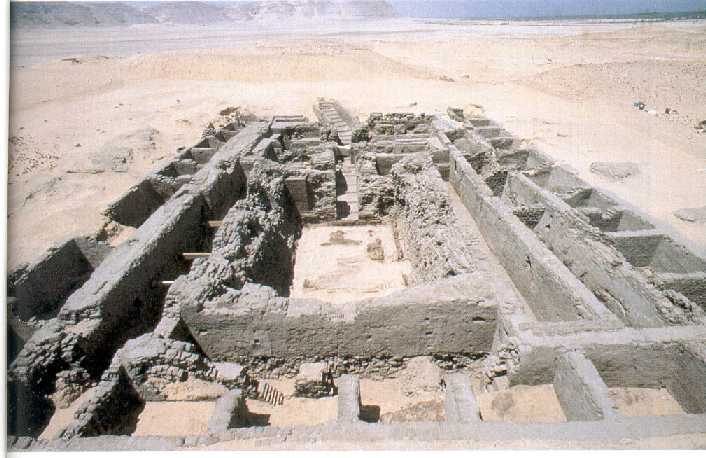
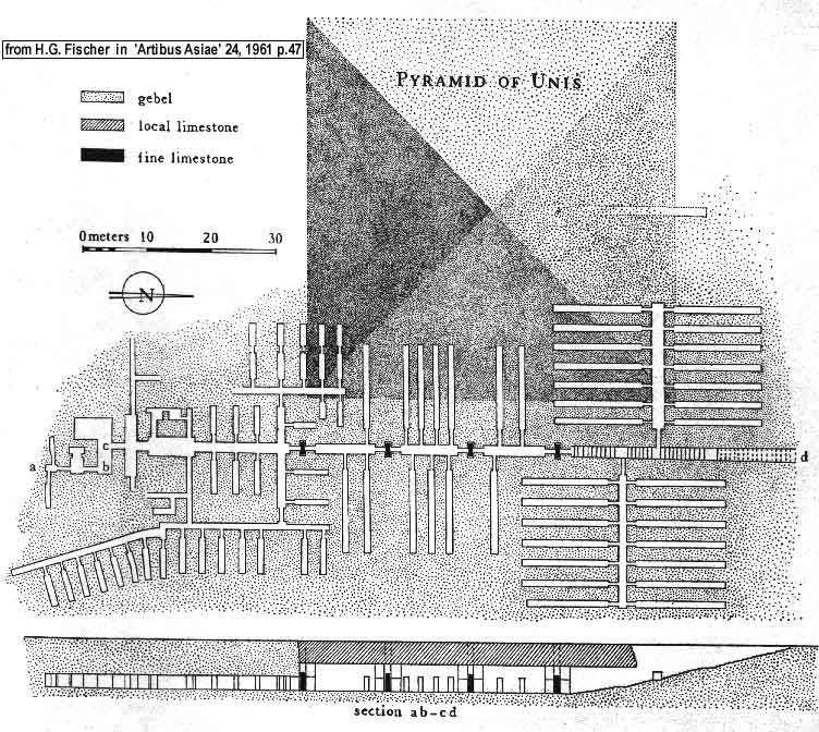
SAQQARA
AND MEMPHIS
The foundation of a new capital in northern Egypt (reasons).
Ancient Memphis (underneath modern Abu-Sir)
- The administrative élite cemetery at North Saqqara
Some
tombs of the 1st Dynasty (Hemaka/S3035, Herneith/S3507,
Nebitka/S3038,
Merka/S3505)
-
Hints at the structures and their developments
-
Quibell, Firth, Emery excavations: the finds
-
Debates on the ownership of the mastabas? The "Abydos vs.
Saqqara" question.
- The state administration subsystem in the Early
Dynastic period
A label
of Hemaka (Den)
-
Epigraphy, practical use and 'year events' (ceremonies, sieges
and else)
-
Parallel with tomb U-j tags: the evolution of the writing
system
Multiplying
titles, officials and offices, both administrative and
religious: Merka stela (from t. S3505)
-
Epigraphic explanation, function and evolution of private
stelae
- Foreign politics: Lower Nubia, Libya, Eastern Desert,
Sinai and Palestine (labels of Aha,
Den,
Qaa)
ABYDOS, UMM EL-QA'AB
- First (and Second) Dynasty royal tombs
- Funerary enclosures
at Kom es-Sultan (North Abydos)
- Architectural and ideological progress: palace façade
enclosure walls, inner tumuli, step pyramids
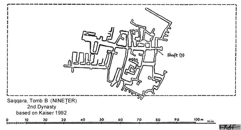
- The shift of the royal necropolis to Saqqara early in the Second
Dynasty
Saqqara royal tombs south of Djoser complex:
A
(Hotepsekhemui), B
(Nineter) e C.
- Evolution of
the underground chambers, function and reference model (royal
palace)
- Hypothesis
on the superstructures
- Hints to the history of the Second Dynasty: old theories and
new evidence:
Civil war (?).
Horus and Seth conflict. Khasekhemwy's re-unification. Buto
and Elephantine excavations
The great
achievement in the reign of Horus-Seth Khasekhemwy (stone
masonry, relief and statuary, military raids, bureaucracy,
foreign relations).
|
60. Djoser
statue
61. Hesyra
wooden panel
|
EARLY OLD
KINGDOM AND THE STATE MATURITY
The state on
the threshold of the full maturity. Hints at the Third
Dynasty
history.
- Monuments and art.
- Central organization. Taxation. Provinces.
Resources exploitation.Long distance trade management.
- Technological specialisation. Cities.
Administration. Writing (progress as against previous
periods).
- The institution of divine kingship and the
refined ideology.
- Conclusions. The fruits of the pharaonic
civilisation's formative tree: the classic period of
the great pyramids.
|
|
 Presentación
del Instituto
Internacional de Egiptología
INDETEC-Aegyptus
Presentación
del Instituto
Internacional de Egiptología
INDETEC-Aegyptus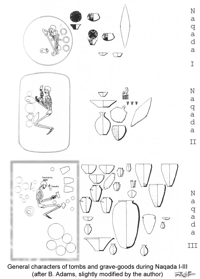